 |
Register Subscribe Login |
| 1. |  | Elliott & Fry 1869 (ca) Sir Charles Lyell, Geologist Carte de visite Wisconsin Historical Society Increase Allen Lapham: Papers, 1825-1930, carte-de-visite collection, WHS Image id: WHi-45315 Elliott & Fry (55 Baker Street, Portman Square) Carte-de-visite portrait of Sir Charles Lyell (1897-1875), Scottish lawyer, geologist, and advocate of uniformitarianism. Handwritten text at the bottom of the image reads, "Sir Chas Lyell, 1869." © Wisconsin Historical Society |
| 2. |  | A. Sonrel (46 School Street, Boston) 1864 (ca) Jean Louis Rodolphe Agassiz, Geologist Carte de visite Wisconsin Historical Society Increase Allen Lapham: Papers, 1825-1930, carte-de-visite collection, WHS Image id: WHi-44730 Carte-de-visite portrait of Jean Louis Rodolphe Agassiz (1807-1873), Swiss-born American zoologist, geologist and glaciologist. Founded the Museum of Comparative Zoology in 1860. Founding member of the National Academy of Sciences in 1863. Agassiz is shown sitting in three-quarter profile. Handwritten inscription at bottom reads, "Agassiz 1864." August Sonrel, to whom this credit refers, was a gifted 19th Century lithographer whom Agassiz had hired a number of years earlier to make images for a monograph on American fish. © Wisconsin Historical Society |
| 3. |  | Unidentified photographer / artist 1865 Professor Pierre Jean Edouard Desor, Geologist Carte de visite Wisconsin Historical Society Increase Allen Lapham: Papers, 1825-1930, carte-de-visite collection, WHS Image id: WHi-45407 Carte-de-visite portrait of Edouard Desor (1811-1882), Swiss geologist and professor at Neuchâtel academy. He chiefly studied the structure of glaciers and Jurassic Echinoderms. Handwritten text at the bottom of image reads, "E. DeSor, Neuchâtel." © Wisconsin Historical Society |
| 4. |  | Henry Ulke 1868 Fielding B. Meek, Paleontologist Carte de visite Wisconsin Historical Society Increase Allen Lapham: Papers, 1825-1930, carte-de-visite collection, WHS Image id: WHi-44756 Henry Ulke (278 Pennslyvania Avenue, Washington D.C., 1865) Carte-de-visite portrait of Fielding B. Meek (1817-1876), American paleontologist. Meek became the Smithsonian Institution's first full-time paleontologist in 1858. Died of tuberculosis December 21, 1876. Shown here sitting in three-quarter profile, wearing a top hat. Handwritten inscription at bottom reads, "F.B.Meek 1868." © Wisconsin Historical Society |
| 5. |  | Louis Jacques Mandé Daguerre 1839 Fossils and Shells Daguerreotype Musée des arts et métiers |
| 6. |  | Unidentified photographer 1845 (ca) Study of Rocks Daguerreotype 19 7/8 x 25 1/6 in J. Paul Getty Museum The J. Paul Getty Trust (84.XT.183) |
| 7. |  | Southworth & Hawes 1850 (ca) Niagara Falls from the Canadian Side Daguerreotype 21.6 x 16.5 cm (8 1/2 x 6 1/2 ins) Metropolitan Museum of Art Gift of I. N. Phelps Stokes, Edward S. Hawes, Alice Mary Hawes, and Marion Augusta Hawes, 1937, Accession Number: 37.14.7 |
| 8. |  | Hugh Lee Pattinson 1840, April Niagara Falls Daguerreotype, whole plate 6.5 x 8.5 ins Newcastle University Library - Special Collections Hugh Lee Pattinson was a British industrialist and metallurgist who visited Canada on a business trip soon after the Daguerreotype method was announced in 1839. This photograph was taken at Niagara Falls and is considered to be amongst the earliest photographs, if not the earliest, taken in Canada. Eight Daguerreotypes by Pattinson are retained by Newcastle University Library. "Canada's First Daguerreian Image", Graham W. Garrett, History of Photography, Issue 20-2, Summer 1996, 101-103 |
| 9. |  | Unidentified photographer / artist 1845 Niagara Falls Book page Google Books Charles Lyell Travels in North America, in the years 1841-2: with Geological Observations on The United States, Canada and Nova Scotia, Two Volumes (London: John Murray, 1845), Chap.XIX, p.92. The Father Louis Hennepin "discovered" and described Niagara Falls in 1677 although there are several other claims for this honor. Sharpe's London Journal, Vol.X, p.50 adds the following with an incorrect spelling of Father Hennepin: Sir C. Lyell, in his recently published Travels, observes : "The Falls of Niagara, though continually in motion, have all the effects of a fixed and unvarying feature in the landscape; and, however strange it may seem, some Daguerreotype representations have been executed with no small success. They not only record the form of the rocks and the islands, but even the leading features of the cataract, and the shape of the rising clouds of spray. I have often wished that Father Hennessin could have taken one of these portraits, and bequeathed it to the geologists of our times. It would have afforded us no slight aid in our speculations respecting the comparative states of the ravine in the seventeenth and nineteenth centuries." The first series of Views of the Falls taken by the Daguerreotype, was executed by J. E. Myall, (Prof. High School,) in September, 1846. |
| 10. |  | William Henry Jackson 1870, 24 August A noon meal in Ferdinand V. Hayden's camp of the U.& Geological Survey. Red Buttes, Wyo. Terr. [Hayden sits at far end of table in dark jacket; W. H. Jackson stands at far right.] National Archives and Records Administration [57-HS-282] |
| 11. |  | John Carbutt 1869, 19 February (published) Fig. 6 ["a great valley of Syenites"] Book illustration Google Books |
| 12. |  | Timothy H. O'Sullivan 1867 Tufa Domes, Pyramid Lake, Nevada Albumen print 20 x 27 cm (7 7/8 x 10 5/8 in) American Art Museum, Smithsonian Institution Museum purchase from the Charles Isaacs Collection made possible in part by the Luisita L. and Franz H. Denghausen Endowment |
| 13. |  | Timothy H. O'Sullivan 1871 Water rhyolites, near Logan Springs, Nevada Albumen print Library of Congress, Prints and Photographs Division Reproduction Number: Reproduction Number: LC-DIG-ppmsca-10022 Originally published: Photographs showing landscapes, geological, and other features of portions of the western territory of the United States, obtained in connection with geographical and geological explorations and surveys west of the 100th meridian, seasons of 1871, 1872, and 1873. [Washington, D.C.] : War Dept., Corps of Engineers, U.S. Army, [1875] Published in: Wheeler's photographic survey of the American West, 1871-1873 by George M. Wheeler ; with 50 landscape photographs by Timothy O'Sullivan and William Bell. New York : Dover Publications, Inc., 1983, Plate 13. |
| 14. |  | Timothy H. O'Sullivan 1871-1874 (survey), (expedition) 6. View of the Grand Canon walls, near mouth of Diamond River. From waterline to first shelf 1,500 feet; from shelf to top of table 3,500 feet. Distance from point of view to top of walls 3 miles. [Wheeler Survey, Explorations and Surveys West of the 100th Meridian] Stereocard, detail Etherton Gallery |
| 15. |  | Timothy H. O'Sullivan 1871-1874 (survey), 1872 (expedition) 15. the "Vermillion Cliff," a typical plateau edge, as seen from Jacobs Pool, Arizona. From its top, a plateau stretches to the right, and from its base another to the left. Their difference of level is 1,500 feet, and the step is too steep for scaling. [Wheeler Survey, Explorations and Surveys West of the 100th Meridian] Stereocard, detail Etherton Gallery |
| 16. |  | Timothy H. O'Sullivan 1871-1874 (survey), 1873 (expedition) 25. Camp Beauty, Canon de Chelle, walls 1,200 feet high, width of Canon at this point about one fourth of a mile. [Wheeler Survey, Explorations and Surveys West of the 100th Meridian] Stereocard, detail Etherton Gallery |
| 17. |  | Timothy H. O'Sullivan 1873 Canyon de Chelle, Walls of the Grand Canyon About 1200 Feet in Height Albumen print 20.3 x 27.6 cm (8 x 10 7/8 in) American Art Museum, Smithsonian Institution Museum purchase from the Charles Isaacs Collection made possible in part by the Luisita L. and Franz H. Denghausen Endowment |
| 18. | 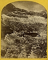 | Timothy H. O'Sullivan 1871-1874 (survey), 1874 (expedition) 47. Alpine lakes and mountain scenery in the Cerro Blanco Mountains, Colorado, 13,000 feet above sea-level. [Wheeler Survey, Explorations and Surveys West of the 100th Meridian] Stereocard, detail Etherton Gallery |
| 19. |  | Unidentified photographer / artist 1870-1880 Book spines from Clarence King "Report of the Geological Exploration of the Fortieth Parallel made by order of the Secretary of War" (Washington: Government Printing Office, 1870-1880) Book spines Donald A. Heald - Rare Books, Prints & Maps Courtesy of Donald A. Heald, #19012 [KING, Clarence (1842-1901), and others] Report of the Geological Exploration of the Fortieth Parallel made by order of the Secretary of War [Text:] Washington: Government Printing Office: [Atlas:] New York: Julius Bien, [Text:]1878-1877-1870-1877-1871-1876-1880, [atlas: no date, but 1870]. 8 volumes only (text: 7 volumes, quarto [11 7/16 x 9 inches]; atlas: 1 volume only [of 2], oblong folio [19 1/4 x 25 1/8 inches]). Text: numerous maps, plates, and illustrations throughout, some coloured, some folding or double-page. Atlas: lithographed throughout, title, 1 uncoloured map, 3 chromolithographic geological maps, 10 lithographic sectional maps showing mining operations, with hand-colouring and colour-printing (2 double-page). Text: uniform original blue cloth, titled in gilt on spine, small tears or scuffing to joints and extremities, atlas: original blue half morocco, titled in gilt on upper cover. With over 4000 pages of text and hundreds of plates, maps and illustrations, this was a landmark publication in American science and in knowledge of the American West. "As a great and epic feat of exploration and adventure, the King Survey surpassed everything else that had been done in the latter-day West…but the most important result of his adventures was the monographs produced with incredible diligence and insight by King and his staff" - Goetzmann. An almost complete set of the final reports of the Geological Exploration of the Fortieth Parallel, better known after its field director, Clarence King, as the King Survey. The reports appeared in seven volumes over a ten-year period, reporting on field work in the American West between 1868 and 1878. This set is lacking only the large separately issued atlas of ten double-sheet geological and topographical maps. It does include the other atlas, Atlas accompanying volume III on Mining Industry (New York: Julius Bien, [no date]), which includes a series of fascinating large scale cross-sectional maps showing mines workings in the area. The King Survey, with those of Hayden, Wheeler, and Powell, was one of the great scientific reconnaisances of the American West made in the fifteen years after the Civil War. King himself, called "the best and brightest man of his generation" by his friend, Henry Adams, was a dynamic leader and a brilliant organizer of field research. His survey, stretching from northern California across Nevada, Utah, Colorado and Kansas, provided a physical cross-section of the vast West, already subdued in a military sense, but only beginning to be understood from a scientific perspective. King was accompanied by an expert crew of scientists, as well as the photographer, Timothy O'Sullivan, whose work provides the basis for the lavish illustrations in King's own Systematic Geology…, the first volume in the set. Other volumes, also extensively illustrated, cover descriptive geology, the mining industry, paleontology, botany, petrography, and O.C. Marsh's pioneering work on dinosaurs, Odontornithes. Schmeckebier Publications…of the surveys pp.38-40; Goetzmann Exploration and Empire pp.438-66; Reese, Stamped with a National Character 76. |
| 20. |  | William Henry Jackson 1874 Title page for "Descriptive Catalogue of the Photographs of the United States Geological Survey of The Territories for The Years 1869 to 1873, inclusive" by W.H. Jackson (Washington: Government Printing Office, 1874) Title page Google Books Preface It has been customary, heretofore, merely to catalogue the results of each season's operations in a few pamphlet pages of numbers and titles only, but the increasing interest in, and demand for the more striking views, calls for a complete descriptive account of the collection, and I have endeavored, in the following pages, to supply as much information as the somewhat limited space allows. The descriptions are mainly compiled from the reports for the corresponding years. The collection, thus far, numbers upward of thirteen hundred landscape negatives, the greater portion of them of subjects that had never been taken, and probably will not be for many years to come, or until the country has advanced into civilization. By no other means could the characteristics and wonderful peculiarities of the hitherto almost unknown western half of our continent be brought so vividly to the attention of the world. That they are appreciated, the demand for them, from all quarters of the globe, amply testifies. It is not to be expected that they- should possess uniform excellence as the conditions under which they were made were as variable as the winds, and the difficulties encountered and surmounted in obtaining many of the most valuable views, are almost incredible. As a whole, however, their excellence is quite marked, and is a trinmph over difficulties. The Indian catalogue includes a list of over one thousand subjects and sixty-six tribes, representing nearly every portion of the western Territories, and their value to the ethnography of the aborigines will soon be very great. They are mostly studies of their habits and costumes, taken in their own villages and among their own mountains, showing their every-day life. They are fast passing away or conforming to the habits of civilization, and there will be no more faithful record of the past than these photographs. To their future historian they will prove invaluable. The subjects made under the direction of this survey formed the nucleus, to which has been added nearly one thousand negatives through the munificent liberality of Wm. Blackmore, esq., a wealthy English gentleman, deeply interested in ethnography. The addition is especially valuable as it embraces many other collections, dating back twenty years. Especial attention is being paid to the subject each season, and additions made to the collections upon every opportunity. |
| 21. |  | William Henry Jackson 1874 Title page for "Catalogue of Photographs of Indians, From Negatives in the Possession of the United States Geological Survey, Collected from Various Sources, and Covering a Period of Twenty-Five Years" by W.H. Jackson (Washington, 1874) Title page Google Books Preface to Indian Catalogue The following series of Indian subjects is made up principally of the valuable additions which have been made to the original collections of this survey, through the munificent liberality of Wm. Blackmore, esq., of England, who has contributed them gratuitously for the advancement of ethnological studies. The collection comprises about one thousand negatives, representing sixty-five tribes, and every possible phase of feature and mode of life. The original collection of this survey, which has formed the nuclens about which to gather others, now numbers about two hundred negatives, chiefly scenes and studies among their habitations in the wilds of the far west. The contributions of Mr. Blackmore comprise, first, a collection of over four hundred negatives, by Schindler, of Washington, D. 0., who had gathered them from various sources, and which go back to the days of the daguerreotype, twenty-five years ago; second, a collection of about forty-five negatives, made to his order, of the Pueblos, Apaches, and NavajoeS, in New Mexico, in 1871; third, a series of over three hundred very valuable negatives, purchased from Alex. Gardner, esq., of Washington, D. C., embracing all the prominent individuals who have visited their Great Father upon delegations during the last ten years. During the past season other delegations have been secured by this survey, in negatives by Bell, Ulke, and Gardner. Additions are being constantly made to the collections, both through the operations of the survey, and of others, so as to place it in a position of national importance. The aborigines are rapidly fading away, and, in the near future, there will be no more trustworthy evidence of what they have been than these faithfully drawn sun-pictures. At present, this catalogue merely enumerates them by tribes and individuals. Eventually a fully descriptive catalogue will be issued. |
| 22. |  | Unidentified photographer 1870 (published) Coal-Beds of Rio Candiota, Rio Grande Do Sul Book illustration Google Books |
| 23. |  | Unidentified photographer n.d. Bone Field on Talbot Hill, 10 miles from Canon City, Colo. Stereoview Jeffrey Kraus Antique Photographics This view is accompanied by a photocopied excerpt from The New Rocky Mountain Tourist, Arkansas Valley and San Juan Guide by Joseph Gladding Pangborn, 1878, that describes this area as a vast bonefield of newly discovered dinosaur fossils. |
| 24. |  | Unidentified photographer n.d. Bone Field on Talbot Hill, 10 miles from Canon City, Colo. Stereoview, detail Jeffrey Kraus Antique Photographics This view is accompanied by a photocopied excerpt from The New Rocky Mountain Tourist, Arkansas Valley and San Juan Guide by Joseph Gladding Pangborn, 1878, that describes this area as a vast bonefield of newly discovered dinosaur fossils. |
| 25. |  | Unknown (French) 1850s (late) No.5 Roche qui pleure [Foret de Fontainbleau] Stereoview Northern Light Gallery |
| 26. |  | Eugène Cuvelier 1863 Quarry at the Sands of Macherin Metropolitan Museum of Art Purchase, Harriette and Noel Levine Gift and Rogers Fund, 1996 Inventory number, photography type and size requested. This photograph was included in In the Forest of Fontainebleau: Painters and Photographers from Corot to Monet, National Gallery of Art, Washington, USA (March 2 through June 8, 2008). |
| 27. |  | Richebourg 1879 (published) Photoglyph of a quarry with descriptions of layers [CarriÞre de Pierre a Batir] [Carte géologique détaillée de la France, Feuille 48.- Paris - Annexes. Perspectives Photographiques. Pl. II] Photoglyph 20 x 24 ins (sheet) Northern Light Gallery |
| 28. |  | Richebourg 1879 (published) Photoglyph of a quarry with descriptions of layers [CarriÞre de Pierre a Batir] (edited detail) [Carte géologique détaillée de la France, Feuille 48.- Paris - Annexes. Perspectives Photographiques. Pl. II] Photoglyph, detail, edited 20 x 24 ins (sheet) Northern Light Gallery |
| 29. |  | Richebourg 1879 (published) Photoglyph of a quarry with descriptions of layers [CarriÞre d'Argile Plastique] [Carte géologique détaillée de la France, Feuille 48.- Paris - Annexes. Perspectives Photographiques. Pl. III] Photoglyph 20 x 24 ins (sheet) Northern Light Gallery |
| 30. |  | Richebourg 1879 (published) Photoglyph of a quarry with descriptions of layers [CarriÞre d'Argile Plastique] (edited detail) [Carte géologique détaillée de la France, Feuille 48.- Paris - Annexes. Perspectives Photographiques. Pl. III] Photoglyph, detail, edited 20 x 24 ins (sheet) Northern Light Gallery |
| 31. |  | C.H. Jones 1887 (published) Brand's Cascade, Luray Caverns. (Drawn from a photograph by C.H. Jones) Magazine illustration Google Books |
| 32. |  | Phillip H. Edgerton (b. 1824) 1864 (ca) Rock on a Pedestal of Ice, Tibet Albumen Print 8 1/2 x 7 3/4 in Peabody Essex Museum |
| 33. |  | Unidentified photographer / artist 1859, 27 April Two workmen in the gravel pit near the Seminary of St Acheul, 27 April 1859. The standing workman is pointing to the in situ flint Albumen print Bibliothèques d'Amiens Métropole This is the first use of photography to support claims for prehistoric evidence and captures the moment that human antiquity was established. On 27 April 1859 Joseph Prestwich and John Evans recovered a flint implement that lay 17 feet below the ground surface in context with the bones of extinct animals such as the mammoth and the woolly rhino in the quarries at St Acheul. They were accompanied by three representatives of the Société des Antiquaries de Picardie (Pinsard, Dufour and Garnier) to witness its discovery, and for a photographer to record the moment. The significance of the find was enormous and was presented to the Royal Society on May 26th 1859. This discovery had been demonstrated by Jacques Boucher de Perthes earlier but little trust was given to his theories but with Prestwich and Evans the evidence was accepted and it proved that man had existed in geological time. Clive Gamble & Robert Kruszynski, 2009, "John Evans, Joseph Prestwich and the stone that shattered the time barrier", Antiquity vol. 83, pp. 461-75 John Evans, Joseph Prestwich and the stone that shattered the time barrier This photograph was published as Fig.2 on p.467. This discovery also featured as a BBC Radio 3 Essay on Strange Encounters. The result was broadcast in April 2007 in the UK. Clive Gamble, August 2008, "Breaking the time barrier" Geoscientist Online, vol. 18.8 Breaking the time barrier |
| 34. |  | Unidentified photographer / artist 1863 Mr. Prestwich shows a photograph of the flint tool "in situ" Book page Google Books Sir Charles Lyell The Geological Evidences of the Antiquity of Man, with remarks on theories of the Origin of Species by Variation, Second American Edition (Philadelphia: George W. Childs, 1863), p.103. There was no one in England whose authority deserved to have more weight in overcoming incredulity in regard to the antiquity of the implements in question than that of Mr. Prestwich, since, besides having published a series of important memoirs on the tertiary formations of Europe, he had devoted many years specially to the study of the drift and its organic remains. His report, therefore, to the Royal Society, accompanied by a photograph showing the position of the flint tool in situ before it was removed from its matrix, not only satisfied many inquirers, but induced others to visit Abbeville and Amiens; and one of these, Mr. Flower, who accompanied Mr. Prestwich on his second excursion to St. Acheul, in June, 1859, succeeded, by digging into the bank of gravel, in disinterring, at the depth of twenty-two feet from the surface, a fine, symmetrically shaped weapon of an oval form, lying in and beneath strata which were observed by many witnesses to be perfectly undisturbed. (1) 1). Geological Quarterly Journal, vol. xvi . p. 190 The work of Mr Prestwich is published in Proceedings of the Royal Society, 1859, and Philosophical Transactions, 1860. |
| 35. |  | Gustav Jõgermayer 1863 Welitz Glacier, East by North from the Foot of the Umbal Glacier Albumen print, mounted on cardboard Albertina © Albertina, Vienna This version includes the Albertina digital watermark in the lower right which is not visible on the original image. |
| 36. |  | Giorgio Sommer 1872, 26 April (taken) Mount Vesuvius, active [L'Eruzione del Vesuvio] Photographic print Library of Congress, Prints and Photographs Division Reproduction Number: LC-DIG-ppmsca-015616 The Library of Congress does not give the photographer for this photograph but it appears to be Giorgio Sommer. [Alan Griffiths: 23 October 2010] |
| 37. |  | Giorgio Sommer 1872 (taken) Mt Vesuvius erupting Glass lantern slide York Museums Trust The York Museums Trust has this photograph attributed to Tempest Anderson. It is actually a copy of an earlier photograph of the eruption of the 26 April 1872 eruption and it appears have been taken by Giorgio Sommer. [Alan Griffiths: 23 October 2010] |
| 38. |  | Unidentified photographer (Italian) 1892 [Lava fields, Italy] Albumen print 6 1/2 x 9 ins Northern Light Gallery |
| 39. |  | Giorgio Sommer 1880s Siracusa Latomie del Paradiso [Italy] Albumen print 7 3/4 x 10 ins Northern Light Gallery |
| 40. |  | Ledru Mauro 1892, 19 August (or later) Etna - Eruzione 1892 - Nuovi monti. 19. Agusto [Italy] Albumen print 7 1/2 x 10 ins Northern Light Gallery |
| 41. |  | Ledru Mauro 1892, 17 August, 1 p.m. Etna - Eruzione di Lave, Lapillo e Massi - Vista dal M.te Faggio ore 1 p.m. 17 Luglio 1892 [Italy] Albumen print 8 x 10 ins Northern Light Gallery |
| 42. |  | Ledru Mauro 1892, 19 August (or later) Etna - Interno del 1 cratere, pressola montagnuola, 19 Agosto 1892 (italy) Albumen print 8 x 10 ins Northern Light Gallery |
| 43. |  | Giorgio Sommer 1910 (created or published) Photographers on hillside photographing Mt. Etna eruption Glass negative Library of Congress, Prints and Photographs Division Reproduction Number: LC-DIG-ggbain-04580 |
| 44. |  | William Jerome Harrison n.d. Pouk Hill nr. Walsall, Basalt Photographic print Lapworth Museum of Geology, University of Birmingham |
| 45. |  | Marc Ferrez, Humberto Saraiva Antúnez, and José Carlos de Carvalho 1888 Moving the Bendégo Meteorite Albumen print 9 1/8 x 12 3/16 ins (23.18 x 30.96 cm) SFMOMA - San Francisco Museum of Modern Art Foto Forum purchase, 2003.118.A-R |
| 46. |  | A.J. Russell 1864-1869 Surveying under difficulties [Photographs taken during construction of the Union Pacific Railroad] Albumen print 28.2 x 35.5 cm Yale University, Beinecke Rare Book and Manuscript Library Call Number: ZZc10 864un, Image ID Number: 1078347 |
| 47. |  | B.F. Baltzly 1871, 14 October [Geological Survey party in camp at Canoe River, October 14. Alfred Selwyn at centre with John Hammond (left centre) and Benjamin Baltzly (right centre)] [Geological Survey of Canada expedition of British Columbia, led by Alfred R. C. Selwyn] Albumen print 17.5 x 23.5 cm (image) 36 x 49.5 cm (mount) Toronto Reference Library Special Collections, Canadian Historical Picture Collection, Identifier: 928-2-31 Photograph taken during Geological Survey of Canada expedition of British Columbia, led by Alfred R. C. Selwyn Printed caption on verso: No. 69993 Geological Survey Party to British Columbia, at Canoe River, October 14th, 1871 10 x 8 Sir William Logan was temporary director of the Geological Survey of Canada in 1871 while Selwyn (the new director) was in British Columbia on the survey during which this photograph was taken. |
| 48. |  | Joseph Burr Tyrell (1858-1957) 1893, 8 June Grand Rapids Sandstone, underlain by Clearwater shale [on the Athabasca River] [1893 expedition to the barren lands [Geological Survey]] Black and white print 10 x 12 cm University of Toronto, Thomas Fisher Rare Book Library Digital ID: P10172 The official report of the expedition was published as: Report on the Doobaunt, Kazan and Ferguson Rivers. Number and date assigned by Tyrrell in album '21, June 8' |
| 49. |  | Dr. Mandeville Thum 1877 (Entered into Congress) [Exterior view of Mammoth Cave] [Views of Mammoth Cave and Vicinity] Stereoview Northern Light Gallery |
| 50. |  | Dr. Mandeville Thum 1877 (Entered into Congress) [Interior view of Mammoth Cave - Magnesium light] [Views of Mammoth Cave and Vicinity] Stereoview Northern Light Gallery |
| 51. |  | Dr. Mandeville Thum 1877 (Entered into Congress) [Interior view of Mammoth Cave - Magnesium light] [Views of Mammoth Cave and Vicinity] Stereoview Northern Light Gallery |
| 52. |  | John A. Mather 1876 Niagara Farm [Titusville, Pennsylvania] Albumen print Northern Light Gallery Note that all the trees have gone and the timber used to build the forest of oil derricks on the horizon. |
| 53. |  | Thomas Annan 1874, 31 March (meeting) Photographs of fossils by Thomas Annan Magazine page Google Books Proceedings of the Natural History Society of Glasgow, from the report of the Meeting of March 31st, 1874, Vol.11 - Part II, 1876, p.252 A number of large and beautiful photographs of slabs of polyzoa, crinoidea, and shells, executed by Mr Thomas Annan, Sauchiehall Street, were exhibited by the President as illustrative of what could be done by photography in producing faithful pictures of the numerous and varied organisms that crowd many of our limestone shales. |
| 54. |  | Dr. Hannes Grobe 2005, 7 April Fluorescent minerals Under UV-A, UV-B and UV-C light Creative Commons - Wikipedia |
| 55. |  | Dr. Hannes Grobe 2005, 7 April Fluorescent minerals [key] Under UV-A, UV-B and UV-C light Creative Commons - Wikipedia Description of fluorescent minerals from page Fluorescence:
|