 |
Register Subscribe Login |
| 1. |  | Unidentified photographer / artist 2010 Northern Egypt showing the Nile Delta Satellite and GIS imagery Google Earth Image © 2010 DigitalGlobe, Map Data © AND |
| 2. |  | Envisat 2004, 28 January Foxe Basin AATSR ESA - European Space Agency ESA 2004, ID number: SEMGIB3AR2E This image covers the Foxe Basin and the southern portion of Baffin Island (Canada) from northeast to southwest, and was processed from data acquired by the AATSR onboard Envisat on 28 January 2004. This is a nighttime thermal image of the Arctic. The ice is whitish blue in colour and covers the Foxe Basin (in the centre-right of the image); the land (covered by snow) appears to be deep blue or black in colour. |
| 3. |  | Unidentified photographer / artist n.d. Indiana Dunes National Lakeshore, Indiana. this color infrared aerial photograph shows a major part of the lakeshore. Vegetation is shown in red. United States Geological Service US Geological Service (Hill, C.L. 24cp) |
| 4. |  | Envisat 2006-2008 (combined data) Hawaii ASAR - Advanced Synthetic Aperture Radar ESA - European Space Agency ESA, ID number: SEM7E4ZVNUF This Envisat radar image features six of Hawaii's eight major volcanic islands. Visible from right to left are the Big Island of Hawaii, Kahoolawe, Maui, Lanai, Molokai and Oahu. In addition to two other major islands, there are also 124 islets. This image was created by combining three Envisat ASAR acquisitions (27 March 2006, 16 April 2007 and 21 January 2008) taken over the same area. The colours in the image result from variations in the surface that occurred between acquisitions. |
| 5. |  | 2000, 17 February Radar Image, Hokkaido, Japan NASA Radar image NASA NASA/JPL/NIMA (Visible Earth v1 ID 1070) |
| 6. |  | Envisat 2006, 10 February The Al Kufrah Oasis in southeastern Libya MERIS - Medium-spectral resolution, imaging spectrometer ESA - European Space Agency ESA, ID number: SEM50PNVGJE Envisat's Medium Resolution Imaging Spectrometer (MERIS), acquired this image of the Al Kufrah Oasis, in southeastern Libya, on 10 February 2006. |
| 7. |  | Envisat 2008, 1 March A fissure on the massive A53A iceberg ASAR - Advanced Synthetic Aperture Radar ESA - European Space Agency ESA, ID number: SEMRCGM5NDF On 1 March 2008 Envisat's Advanced Synthetic Aperture Radar (ASAR) instrument spotted a huge fissure running south to north through the massive A53A iceberg located just east of the South Georgia Island (visible at image bottom) in the southern Atlantic Ocean. ASAR is able to produce high-quality images of icebergs and ice sheets and is capable of differentiating between different types of ice because it is able to see through clouds and local darkness - conditions often found in polar areas. |
| 8. |  | 2000, 6 October Washington, D.C. NASA Terra/ASTER image NASA NASA GSFC, MITI, ERSDAC, JAROS, and U.S./Japan ASTER Science Team (Visible Earth v1 ID 5369) |
| 9. |  | Envisat 2009 (combined data) Ganges' dazzling delta ASAR - Advanced Synthetic Aperture Radar ESA - European Space Agency ESA, ID number: SEM03ME3GXF This Envisat image highlights the Ganges Delta, the world's largest delta, in the south Asia area of Bangladesh (visible) and India. The delta plain, about 350-km wide along the Bay of Bengal, is formed by the confluence of the rivers Ganges, the Brahmaputra and Meghna. As radar images represent surface backscatter rather than reflected light, there is no colour in a standard radar image. This image was created by combining three Envisat Advanced Synthetic Aperture Radar acquisitions (20 January 2009, 24 February 2009 and 31 March 2009) taken over the same area. The colours in the image result from variations in the surface that occurred between acquisitions. |
| 10. |  | Envisat 2008, 4 September A patch of Sargassum MERIS - Medium-spectral resolution, imaging spectrometer ESA - European Space Agency ESA, ID number: SEMDFX9WYNF A patch of Sargassum - free-floating seaweed often referred to in nautical lore for entangling ships - captured on 4 September 2008 by Envisat's MERIS instrument off the eastern coast of the United States in the North Atlantic. The patch is centred at 35¦45'N and 66¦21'W and is about 45 km across. |
| 11. | 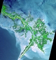 | Unidentified photographer / artist 2001, 24 May Mississippi River Delta Digital image, Advanced Spaceborne thermal Emission and Reflection Radiometer NASA NASA Planetary Photo Journal Collection, UID: SPD-PHOTJ-PIA03497, Image ID: 120970 As the Mississippi River enters the Gulf of Mexico, it loses energy and dumps its load of sediment that it has carried on its journey through the mid continent. This pile of sediment, or mud, accumulates over the years building up the delta front. As one part of the delta becomes clogged with sediment, the delta front will migrate in search of new areas to grow. The area shown on this image is the currently active delta front of the Mississippi. The migratory nature of the delta forms natural traps for oil. Most of the land in the image consists of mud flats and marsh lands. There is little human settlement in this area due to the instability of the sediments. The main shipping channel of the Mississippi River is the broad stripe running northwest to southeast. This image was acquired on May 24, 2001 by the Advanced Spaceborne Thermal Emission and Reflection Radiometer (ASTER) on NASA's Terra satellite. With its 14 spectral bands from the visible to the thermal infrared wavelength region, and its high spatial resolution of 15 to 90 meters (about 50 to 300 feet), ASTER will image Earth for the next 6 years to map and monitor the changing surface of our planet. ASTER is one of five Earth-observing instruments launched December 18,1999, on NASA's Terra satellite. The instrument was built by Japan's Ministry of Economy, Trade and Industry. A joint U.S./Japan science team is responsible for validation and calibration of the instrument and the data products. Dr. Anne Kahle at NASA's Jet Propulsion Laboratory, Pasadena, California, is the U.S. Science team leader; Bjorn Eng of JPL is the project manager. The Terra mission is part of NASA's Earth Science Enterprise, a long-term research and technology program designed to examine Earth's land, oceans, atmosphere, ice and life as a total integrated system. The broad spectral coverage and high spectral resolution of ASTER will provide scientists in numerous disciplines with critical information for surface mapping, and monitoring dynamic conditions and temporal change. Example applications are: monitoring glacial advances and retreats; monitoring potentially active volcanoes; identifying crop stress; determining cloud morphology and physical properties; wetlands evaluation; thermal pollution monitoring; coral reef degradation; surface temperature mapping of soils and geology; and measuring surface heat balance. Size: 54 x 57 km (33 x 39 miles) Location: 40.7 deg. North lat., 29.2 deg. West long. 89.4 Orientation: North at top Image Data: ASTER bands 1,2, and 3. Original Data Resolution: 15 m Date Acquired: May 24, 2001 |
| 12. |  | Unidentified photographer / artist 2000, 8 August Mt. St. Helens ASTER NASA NASA/GSFC/METI/ERSDAC/JAROS, and U.S./Japan ASTER Science Team This ASTER image of Mt. St. Helens volcano in Washington was acquired on August 8, 2000 and covers an area of 37 by 51 km. Mount Saint Helens, a volcano in the Cascade Range of southwestern Washington that had been dormant since 1857, began to show signs of renewed activity in early 1980. On 18 May 1980, it erupted with such violence that the top of the mountain was blown off, spewing a cloud of ash and gases that rose to an altitude of 19 kilometers. The blast killed about 60 people and destroyed all life in an area of some 180 square kilometers (some 70 square miles), while a much larger area was covered with ash and debris. It continues to spit forth ash and steam intermittently. As a result of the eruption, the mountain's elevation decreased from 2,950 meters to 2,549 meters. The image is centered at 46.2 degrees north latitude, 122.2 degrees west longitude. |
| 13. |  | Envisat 2009, 20 February Himalayan Mountains MERIS - Medium-spectral resolution, imaging spectrometer ESA - European Space Agency ESA, ID number: SEMQVVJIWZF This Envisat image captures Asia's diverse topography, altitude and climate with the snow-sprinkled Himalayan Mountains marking the barrier between the peaks of the Tibetan Plateau (top) in Central Asia and the plains of Nepal, Buthan and India in the Indian subcontinent. In this false-colour image, lush or green vegetation appears bright red. This image was acquired by Envisat's Medium Resolution Imaging Spectrometer (MERIS) instrument on 20 February 2009, working in Full Resolution mode to provide a spatial resolution of 300 m. |
| 14. |  | Envisat 2004, 24 November Ubari and Murzuq sand seas, Libya MERIS - Medium-spectral resolution, imaging spectrometer ESA - European Space Agency ESA, ID number: SEMXAVRMD6E This Envisat image shows Ubari and Murzuq sand dune seas in the Fezzan region of southwestern Libya, close to the border with Algeria. Envisat's Medium Resolution Imaging Spectrometer (MERIS), working in Full Resolution mode to provide a spatial resolution of 300 metres, acquired this image on 24 November 2004. |
| 15. |  | Terra 2005, 2 December Rub' al Khali, Arabia ASTER NASA NASA/GSFC/METI/ERSDAC/JAROS, and U.S./Japan ASTER Science Team, PIA11084 The Rub' al Khali is one of the largest sand deserts in the world, encompassing most of the southern third of the Arabian Peninsula. It includes parts of Oman, United Arab Emirates, and Yemen. The desert covers 650,000 square kilometers, more than the area of France. Largely unexplored until recently, the desert is 1000 km long and 500 km wide. The first documented journeys made by Westerners were those of Bertram Thomas in 1931 and St. John Philby in 1932. With daytime temperatures reaching 55 degrees Celsius, and dunes taller than 330 meters, the desert may be one of the most forbidding places on Earth. The image was acquired December 2, 2005, covers an area of 54.8 x 61.9 km, and is located near 20.7 degrees north latitude, 53.6 degrees east longitude. |
| 16. |  | Envisat 2004, 24 February Guinea-Bissau MERIS - Medium-spectral resolution, imaging spectrometer ESA - European Space Agency ESA, ID number: SEMAK41XDYD Acquired 24 February 2004 by Envisat's Medium Resolution Imaging Spectrometer (MERIS), the most striking feature in this image is the contrast between the desert areas of Senegal in the north to the vegetated coastal plains of Guinea-Bissau, The Gambia and southern Senegal (shown in red on the image). The country of Guinea-Bissau also incorporates the Bijagos Archipelago. These islands lie off the coast opposite the River Ge'ba estuary. The Bijagos includes 15 large islands with numerous smaller ones. There are separated from the mainland and the capital Bissau, at the mouth of the river, by a 16 km channel. The green colour of the sea around the islands is caused by sediment being swept out to sea from the river. To the north of the image in Senegal we can see clearly the "hook-shaped" Cape Verde peninsula. At the end of the peninsula is the country's largest city and capital, Dakar. The image has 300 metre spatial resolution. |
| 17. |  | NASA 2012, 28 March Moscow at Night Digital image NASA NASA, 638098main_image_2221_1600-1200 Moscow appears at the center of this nighttime image photographed by the Expedition 30 crew aboard the International Space Station, flying at an altitude of approximately 240 miles on March 28, 2012. A solar array panel for the space station is on the left side of the frame. The view is to the north-northwest from a nadir of approximately 49.4 degrees north latitude and 42.1 degrees east longitude, about 100 miles west-northwest of Volgograd. The Aurora Borealis, airglow and daybreak frame the horizon. |
| 18. |  | Unidentified photographer / artist 1999, 18 December Patagonia Glacier, Chile Digital image, Advanced Spaceborne thermal Emission and Reflection Radiometer NASA NASA/GSFC/METI/ERSDA C/JAROS, and U.S./Japan ASTER Science Team , NASA Planetary Photo Journal Collection, UID: SPD-PHOTJ-PIA02670, Image ID: 113788 This ASTER images was acquired on May 2, 2000 over the North Patagonia Ice Sheet, Chile near latitude 47 degrees south, longitude 73 degrees west. The image covers 36 x 30 km. The false color composite displays vegetation in red. The image dramatically shows a single large glacier, covered with crevasses. A semi-circular terminal moraine indicates that the glacier was once more extensive than at present. ASTER data are being acquired over hundreds of glaciers worldwide to measure their changes over time. Since glaciers are sensitive indicators of warming or cooling, this program can provide global data set critical to understand climate change. Advanced Spaceborne Thermal Emission and Reflection Radiometer (ASTER) is one of five Earth-observing instruments launched December 18, 1999, on NASA's Terra satellite. The instrument was built by Japan's Ministry of International Trade and Industry. A joint U.S./Japan science team is responsible for validation and calibration of the instrument and the data products. Dr. Anne Kahle at NASA's Jet Propulsion Laboratory, Pasadena, Calif., is the U.S. Science team leader; Moshe Pniel of JPL is the project manager. ASTER is the only high resolution imaging sensor on Terra. The primary goal of the ASTER mission is to obtain high-resolution image data in 14 channels over the entire land surface, as well as black and white stereo images. With revisit time of between 4 and 16 days, ASTER will provide the capability for repeat coverage of changing areas on Earth's surface. The broad spectral coverage and high spectral resolution of ASTER will provide scientists in numerous disciplines with critical information for surface mapping, and monitoring dynamic conditions and temporal change. Example applications are: monitoring glacial advances and retreats, monitoring potentially active volcanoes, identifying crop stress, determining cloud morphology and physical properties, wetlands Evaluation, thermal pollution monitoring, coral reef degradation, surface temperature mapping of soils and geology, and measuring surface heat balance. |
| 19. |  | Unidentified photographer / artist 1994-1995 Altamaha River Delta, Georgia Sea Islands Digital image, Airborne Synthetic Aperture Radar (AIRSAR) NASA NASA/JPL/University of Edinburgh, NASA Planetary Photo Journal Collection, UID: SPD-PHOTJ-PIA03157, Image ID: 128740 The history of sea islands in the Altamaha River delta on the coast of Georgia is revealed in this image produced from data acquired by the Airborne Synthetic Aperture Radar (AIRSAR), developed and operated by NASA's Jet Propulsion Laboratory, Pasadena, Calif. The outlines of long-lost plantation rice fields, canals, dikes and other inlets are clearly defined. Salt marshes are shown in red, while dense cypress and live oak tree canopies are seen in yellow-greens. Agricultural development of the Altamaha delta began soon after the founding of the Georgia Colony in 1733. About 25 plantations were located on the low-lying islands and shores by the 19th century, taking advantage of the rich alluvial flow and annual inundation of water required by some crops. The first major crop was indigo; when demand for that faded, rice and cotton took its place. A major storm in 1824 destroyed much of the town of Darien (upper right) and put many of the islands under 20 feet of water. The Civil War ended the plantation system, and many of the island plantations disappeared under heavy brush and new growth pine forests. Some were used as tree farms for paper and pulp industries, while the Butler Island (center left) plantation became a wildlife conservation site growing wild sea rice for migrating ducks and other waterfowl. Margaret Mitchell is reputed to have used the former owner of the Butler Plantation as a basis for the Rhett Butler character in her novel "Gone With The Wind," taking the first name from Rhett's Island (lower right). These data were obtained during a 1994-95 campaign along the Georgia coast. AIRSAR's ability to detect vegetation canopy density, hydrological features and other topographic characteristics is a useful tool in landscape archaeology. AIRSAR flies aboard a NASA DC-8 based at NASA's Dryden Flight Research Center, Edwards, Calif. The analysis on the data shown was accomplished by Dr. Gary Mckay, Department of Archaeology and Geography, and Ian Morrison, Department of Archaeology, both of the University of Edinburgh (Scotland). AIRSAR is part of NASA's Earth Enterprise program. JPL is managed by the California Institute of Technology, Pasadena. |
| 20. |  | ERS-1, ERS-2 1995-1997 (combined data) A mosaic of Northeast China Radar images ESA - European Space Agency ESA - University of Jena, Chinese Academy of Forestry, ID number: SEMFIFIO9PE This mosaic image is based on on ERS-1 and -2 combined data and covers a large region of Northeast China. More than 500 radar images acquired between 1995 and 1997 were used to generate the mosaic. In the false colour composite, red corresponds to the ERS-1 and -2 coherence (matching data), green to the ERS-1 SAR intensity and blue to the ERS-1 and -2 intensity difference. Forests appear in green, agricultural areas appear in orange or yellow, depending on whether the images were acquired in winter or not. Steppe and marsh land surfaces along the Mongolian border appear in red. The green patches in the centre of these regions correspond to the frozen surface of lakes Hulun Nur and Buir Nur. |
| 21. |  | Unidentified photographer / artist 2002-2003 Oil Slicks on Lake Maracaibo, Venezuela Digital image, Multi-angle Imaging SpectroRadiometer (MISR) NASA NASA/GSFC/LaRC/JPL, MISR Team, NASA Planetary Photo Journal Collection, UID: SPD-PHOTJ-PIA04331, Image ID: 113517 occurred on Lake Maracaibo in northwestern Venezuela between December 2002 and January 2003, and were observed by various satellite instruments. These images from the Multi-angle Imaging SpectroRadiometer (MISR) provide new information relating to one such event near the center of Lake Maracaibo on December 26, 2002. In unpolluted areas, the water surface is "ruffled" by wind and the resulting wave facets divert reflected rays into many directions. An oil film dampens the presence of small wind-driven "capillary" waves, resulting a smoother, more mirror-like surface. Also, oil is more strongly absorbing than the surrounding water. Therefore, at most viewing angles, a surface slick will appear darker than the surrounding unpolluted areas, whereas near the specular angle (the angle at which a perfect mirror reflects light) it will appear brighter. Simultaneous observation at multiple view angles therefore enhances the reliability of oil-slick detection using optical imaging. An example of how the optical contrast of an oil film on a water surface changes as a function of viewing angle is illustrated by these false-color MISR images, comprised of near-infrared, red and blue spectral data at three different angles, using the vertical-viewing camera (left), the 26¦-forward-viewing camera (center) and the 46¦-forward-viewing camera (right). A swirly area in the middle of the lake appears darker than the surrounding waters at both the nadir and 46¦ views, but brighter than the surrounding waters at the 26¦ view. Of the three images, only the 26¦ camera observes close to specular reflection angle. Lake Maracaibo is the largest lake in South America. The lake is somewhat saline, since it is connected to the Gulf of Venezuela by a narrow strait in the north. Venezuela is the largest oil producing nation in the Western Hemisphere, and the Lake Maracaibo basin includes the largest oil fields and almost a quarter of this nation's population. The Multi-angle Imaging SpectroRadiometer observes the daylit Earth continuously from pole to pole, and every 9 days views the entire globe between 82 degrees north and 82 degrees south latitude. These data products were generated from a portion of the imagery acquired during Terra orbit 16081. The panels cover an area of 72 kilometers x 225 kilometers, and utilize data from blocks 81 to 83 within World Reference System-2 path 8. MISR was built and is managed by NASA's Jet Propulsion Laboratory, Pasadena, CA, for NASA's Office of Earth Science, Washington, DC. The Terra satellite is managed by NASA's Goddard Space Flight Center, Greenbelt, MD. JPL is a division of the California Institute of Technology. |
| 22. |  | ERS-2 1995, 21 April (after launch) Mosaic of different ERS-2 results Various imaging systems ESA - European Space Agency ESA, ID number: ESAHSSUTYWC Like its predecessor ERS-1 (launched in July 1991 by an Ariane 4 and successfully operational in-orbit at an altitude of some 780 km), the ERS-2 satellite launched on 21.04.95 by an Ariane 4, is monitoring the Earth day and night under all weather conditions thanks to its powerful sharp-eyed, cloud-piercing radars. ERS-2 carries on board an instrument to help monitor the ozone layer around the Earth. |
| 23. |  | Unidentified photographer / artist 1967, 20 November Mosaic of Clouds from ESSA-5 satellite NASA NASA Center: Headquarters, Image: 67-H-1566 This digital mosaic of cloud pictures was taken by the Environmental Science Services Administration (ESSA) 5 satellite on September 14, 1967. It shows more than a dozen storm areas, including hurricanes Beulah, Dora, Chloe, Monica, and Nannette. The picture signals, received in analog form from the satellite, were sampled at short time intervals, and numbers were assigned according to the brightness indicated by the basic signal. The computer then located each digital value and precise map location. The computer tape containing this information was then displayed on a television-like tube (kinescope) and photographed. The result, a mosaic. The first ESSA satellite was launched from Cape Canaveral, Florida, on February 3, 1966. |
| 24. |  | Unidentified photographer / artist 1997, 9 October South Polar Projection of Earth Digital image NASA NASA Planetary Photo Journal Collection, UID: SPD-PHOTJ-PIA00729, Image ID: 119174 This view of the Earth shows a wonderfully unique but physically impossible view of the southern hemisphere and Antarctica. While a spacecraft could find itself directly over the Earth's pole, roughly half of the image should be in darkness! This view was created by mosaicing together several images taken by Galileo over a 24 hour period and projecting them as they would be seen from above the pole. The continents of South America, Africa, and Australia are respectively seen at the middle left, upper right, and lower right. The slightly bluish ice and snow of Antarctica include large ice shelves (upper left, lower middle), a broad fan of broken offshore pack ice (lower left and middle) and continental glaciers protruding into the sea (lower right). The regularly spaced weather systems are prominent. Most spacecraft traveling near the Earth's poles are in very low Earth orbit, and cannot acquire panoramic shots like this one. Galileo's view of the southern hemisphere, combined with the spacecraft's special spectral properties (four separate narrowband filters that measure the brightness of reflected light at specific infrared wavelengths), led to a number of unique observations. For example, Galileo's cameras distinguished between ice and high stratospheric clouds, allowing scientists to study the correlation between these clouds and growth of the ozone hole. The Jet Propulsion Laboratory, Pasadena, CA manages the mission for NASA'is Office of Space Science, Washington, DC. |
| 25. |  | Unidentified photographer / artist 1991 (before) Satellite photograph of the earth, Red Sea, Africa, Arabia, Indian and Atlantic Oceans, and wind patterns. United States Geological Service US Geological Service (Digital File:hcl00006) |
| 26. |  | 2002, 8 February The Blue Marble NASA Visualization NASA NASA Goddard Space Flight Center Image by Reto Stöckli (land surface, shallow water, clouds). Enhancements by Robert Simmon (ocean color, compositing, 3D globes, animation). Data and technical support: MODIS Land Group; MODIS Science Data Support Team; MODIS Atmosphere Group; MODIS Ocean Group Additional data: USGS EROS Data Center (topography); USGS Terrestrial Remote Sensing Flagstaff Field Center (Antarctica); Defense Meteorological Satellite Program (city lights). |