Unidentified photographer / artist, n.d., Indiana Dunes National Lakeshore, Indiana. this color infrared aerial photograph shows a major part of the lakeshore. Vegetation is shown in red., United States Geological Service, LL/6621
Envisat, 2006, 10 February, The Al Kufrah Oasis in southeastern Libya, MERIS - Medium-spectral resolution, imaging spectrometer, ESA - European Space Agency, LL/37419
Envisat, 2008, 1 March, A fissure on the massive A53A iceberg, ASAR - Advanced Synthetic Aperture Radar, ESA - European Space Agency, LL/37421
2000, 6 October, Washington, D.C., NASA Terra/ASTER image, NASA, LL/6842
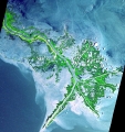
Envisat, 2009 (combined data), Ganges' dazzling delta, ASAR - Advanced Synthetic Aperture Radar, ESA - European Space Agency, LL/37422
Envisat, 2008, 4 September, A patch of Sargassum, MERIS - Medium-spectral resolution, imaging spectrometer, ESA - European Space Agency, LL/37423
Unidentified photographer / artist, 2001, 24 May, Mississippi River Delta, Digital image, Advanced Spaceborne thermal Emission and Reflection Radiometer, NASA, LL/36979
Unidentified photographer / artist, 2002-2003, Oil Slicks on Lake Maracaibo, Venezuela, Digital image, Multi-angle Imaging SpectroRadiometer (MISR), NASA, LL/36980
ERS-2, 1995, 21 April (after launch), Mosaic of different ERS-2 results, Various imaging systems, ESA - European Space Agency, LL/37418
Unidentified photographer / artist, 1967, 20 November, Mosaic of Clouds from ESSA-5 satellite, NASA, LL/37706
Unidentified photographer / artist, 1997, 9 October, South Polar Projection of Earth, Digital image, NASA, LL/36978
Unidentified photographer / artist, 1991 (before), Satellite photograph of the earth, Red Sea, Africa, Arabia, Indian and Atlantic Oceans, and wind patterns., United States Geological Service, LL/6625
2002, 8 February, The Blue Marble, NASA Visualization, NASA, LL/6840