| |
Galileo Orbiter
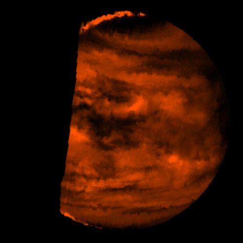
Infrared Image of Low Clouds on Venus
1996, 29 January
Near Infrared Mapping Spectrometer
NASA
NASA/JPL, PIA00124
LL/37362
This false-color image is a near-infrared map of lower-level clouds on the night side of Venus, obtained by the Near Infrared Mapping Spectrometer aboard the Galileo spacecraft as it approached the planet's night side on February 10, 1990. Bright slivers of sunlit high clouds are visible above and below the dark, glowing hemisphere. The spacecraft is about 100,000 kilometers (60,000 miles) above the planet. An infrared wavelength of 2.3 microns (about three times the longest wavelength visible to the human eye) was used. The map shows the turbulent, cloudy middle atmosphere some 50-55 kilometers (30- 33 miles) above the surface, 10-16 kilometers or 6-10 miles below the visible cloudtops. The red color represents the radiant heat from the lower atmosphere (about 400 degrees Fahrenheit) shining through the sulfuric acid clouds, which appear as much as 10 times darker than the bright gaps between clouds. This cloud layer is at about -30 degrees Fahrenheit, at a pressure about 1/2 Earth's surface atmospheric pressure. Near the equator, the clouds appear fluffy and blocky; farther north, they are stretched out into East-West filaments by winds estimated at more than 150 mph, while the poles are capped by thick clouds at this altitude.
| |