| |
Climbing trail towards Mount Everest
2020
Satellite image, with digital layers, cropped
ESA - European Space Agency
Copyright: Contains modified Copernicus Sentinel data (2020), processed by the Department of Geosciences, University of Oslo
LL/113767
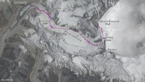
In this Copernicus Sentinel-2 image of Mount Everest, the eastern side of the mountain is obstructed by clouds, while the normal route from the Nepalese side is clearly visible. The GPS trajectories of the climbers on this route are plotted in purple.
The Copernicus Sentinels are a fleet of dedicated EU-owned satellites, designed to deliver the wealth of data and imagery that are central to the European Union's Copernicus environmental programme.
The European Commission leads and coordinates this programme, to improve the management of the environment, safeguarding lives every day. ESA is in charge of the space component, responsible for developing the family of Copernicus Sentinel satellites on behalf of the European Union and ensuring the flow of data for the Copernicus services, while the operations of the Copernicus Sentinels have been entrusted to ESA and EUMETSAT.
| |