| |
Jerusalam
1915
Map
Archive.org
LL/53745
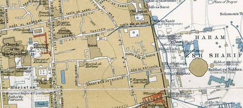
George Adam Smith (ed.), 1915, Atlas of the Historical Geography of the Holy Land, (London: Hodder and Stoughton)
The building labeled "Sarai" is commonly known as "Lady Tonsok's Palace" (formerly the Hospice of St. Helena) on e-Taqiya Ma'alot HaMidrasha St. An earlier name for the street was "Akabat at Takiyeh" (Lady Street).
archive.org/stream/AtlasOfTheHistoricalGeographyOfTheHolyLand/AtlasOfTheHistoricalGeographyOfTheHolyLand-smith#page/n2/mode/1up
With thanks to Yuval Yairi for his assistance in finding this location (Facebook, 29 March 2014).
| |